Data sets for Ocean winds over the Tropical Pacific
For all these data sets the wind field is a vector with u
(South to North) and v (West to East) components. Units are
meters/second. The main interest in these data sets is combining the two
sets of wind field spatial measurements to produce a better estimate. The
data from the National Center for Environmental Prediction is the result
of a complicated assimilation process using available observational data
and a large physical model of the atmosphere.
All data are centered around November 7th, 1996 (day 312/366).
During this time a large tropical cyclone (Dale) was present in
the data region.
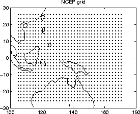
- Gridded climate analysis (NCEP) wind data
at four time intervals on November 7, 1996.
Data set is a 1008 X 10 table with the first two columns
the grid position in longitude and latitude. The remaining 8
columns are the 4 pairs of u and v components.
[get data]
| DAY | TIME | ID |
| 312.00 | 00Z | 1 |
| 312.25 | 06Z | 2 |
| 312.50 | 12Z | 3 |
| 312.75 | 18Z | 4 |
| for a region of the Pacific: |
 |
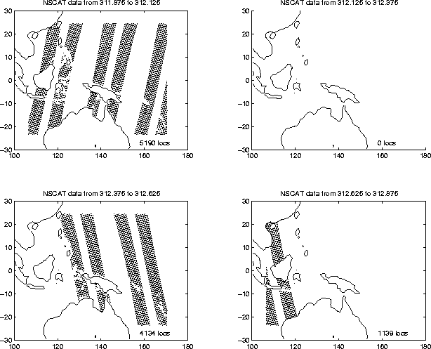
- NSCAT surface wind measurements
from 9PM Nov 6th
through 3AM Nov 8th, 3 hours on either side of the NCEP output and
restricted to the same region in the
Pacific. The data have been aggregated into 6 hour blocks to
correspond to the NCEP time periods. Note that because of the
orbit of the satellite, measurements locations are irregular and
so each record has a separate location (see the plot link
mentioned above). Each data set is a table with 5
columns, with values: longitude, latitude, u, v, and the exact
time of measurement.
- [get data]
time period 1 (311.876, 312.125)
- No data time period 2 (312.126, 312.375)
- [get data]
time period 3 (312.126, 312.375)
- [get data]
time period 4 (312.626, 312.875)

